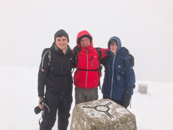
Well, we completed Ben Nevis on the Bank Holiday weekend, summiting the UK’s highest mountain.
Driving and Camping
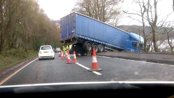
We decided to head up to Ben Nevis earlier in the week, taking advantage of the long Easter weekend. However, the problem with long bank holiday weekends is always traffic – and there was lots of traffic! The king of average speed checks (the M6) resulted in a significant delay to our journey. This was worsened as we passed through Loch Lomond: a lorry had skidded on the A82 and jackknifed, meaning Friday’s bank holiday traffic had to share one lane controlled by temporary lights.

Finally, we arrived at Fort William and continued to Glen Nevis Campsite, which is a fantastic campsite right at the foot of the ‘mountain path’ to the summit of Ben Nevis. The campsite has a great little shop (which, importantly, serves good coffee) and all the usual amenities. There’s also a restaurant a few minutes walk down the road, owned by the same company, who do fantastic food. The campsite is good for everyone on the camping spectrum, from hardcore backpackers (although I’d expect wild camping if you’re that hardcore) to cara-camping families.
Unfortunately, the weather on the first night was terrible. The weather forecast predicted a temperature low of 8°C during the night so I opted to take my three season sleeping bag. Well, it was far lower than 8°C and I spent my first night freezing – I think my Fitbit clocked just 3hrs and 28mins sleep. Great!
Hiking
Weather
Hiking Ben Nevis can become quite difficult – it’s northern location and prominence means it often is hit with the worst weather. The weather also frequently changes, one day the weather forecast will be for intermittent cloud and the following day it will be forecasting heavy snow and strong winds. Plan for the worst weather but hope for the best. Here are some good places to check the weather for hiking:
- Mountain Weather Information Service (MWIS)
- MetOffice
- AccuWeather
Also, there’s a great app (it’s not free unfortunately) which is highly accurate with weather forecasting using hyperlocal weather forecasting – DarkSky. The website is a bit poor, but the app is fantastic. It’s great as it shows you when precipitation is on it’s way, minute by minute (in my experience it’s usually ± 3 minute accuracy) and how heavy it will be etc. Novice or expert, I’d download the app!
Kitlist
There’s kind of a bear minimum of kit you need to be safe, as below:
- Decent rucksack
- Plenty of water
- Food for the day, and spare (high protein and carbs)
- First aid kit, including a foil blanket
- Multiple, insulating layers (a base layer, a mid layer and waterproofs)
- Waterproofs – both coat and trousers
- Good boots (waterproof and ankle support)
- Hiking socks, and a spare pair
- Map
- Compass
- Survival bag
- Sunglasses (sun is strong on the summit)
Also, in winter conditions (summer months can also constitute winter conditions on Ben Nevis) you should take:
- Hat
- Scarf
- Gloves
- Crampons
- Ice Axe
Route

The route is fairly easy if you’re taking the mountain path (see my other posts soon for some more adventurous routes: experience hikers required) – it’s a follow up and follow down. This is the easiest way if you’re hiking Ben Nevis. You start by walking up a moderately steep path, to Lochan Meall An T-suidhe (otherwise known as the Halfway Loch). You should note that there’s a weird little bit where the path seems to fork: there’s one path going immediately straight, and other doubling back on yourself. It’s the latter one you’ll need to take – you’ll recognise you’re there by the Footpath post in the ground. Always double back on yourself, you’ll end up with difficulties if you go straight.
Once past the Loch, you continue following the path up – it’s easy to keep on track in good weather and the Cairns (piles of stones) are there to guide you if not. As I mentioned above, weather changes quickly on the mountain which is why you need a map and compass.